Tuesday, 30 July 2013

Glacier National Park: over the Piegan Pass to Many Glacier Hotel, with some obstacles

We checked out of the Lake McDonald Lodge and would be staying on the Eastern side of the park for a few days. Even through it was 13 miles, there was no doubt that we'd choose the harder walk once we learned that it would cross the Continental Divide and take us on foot to the next hotel - the Many Glacier Hotel.

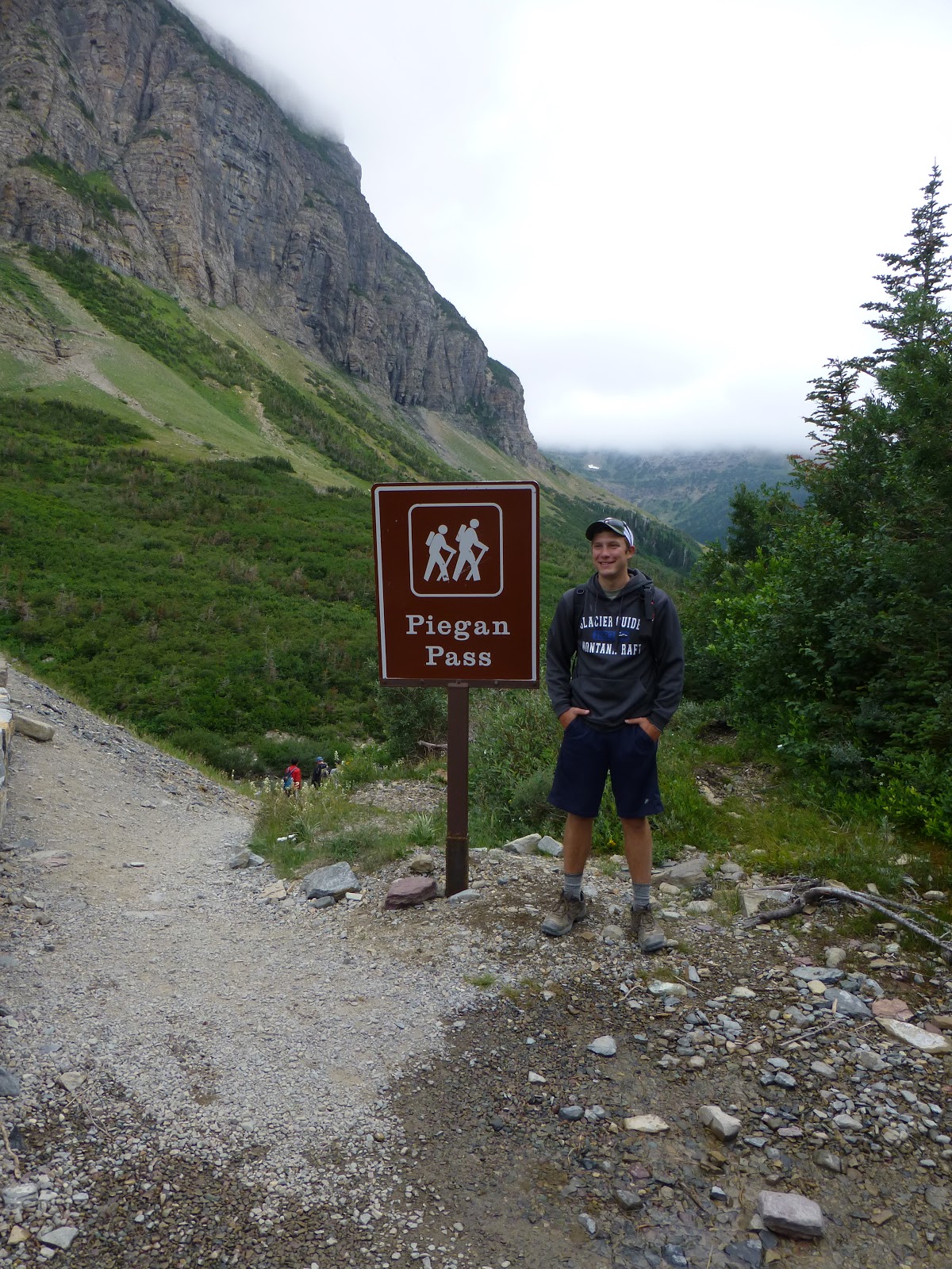
Once again, we drove along the Going to the Sun Road and gained a lot of height. I suggested that we needed a butch guide (who would save us from the bears) to pose in front of the Piegan Pass sign. Clay took my feed line and asked whether he would do instead.

The path gained height gradually through a mixture of woodland and lovely flower meadows, crossing a few fast flowing streams. We had a little rain, but it only lasted long enough for us to put our waterproofs on before stopping. We also came across a mule deer.
Just as we could see the open mountainside ahead, we passed through a final meadow. This was the best of all, with a profusion of gentians and plenty of other colour. We could see the pass in the clouds in the distance, with the path going diagonally across the mountain, requiring us to cross a couple of patches of snow.
 

This was quite a long stretch and, although not steep, we were at 7,600'. By the time we got to the Continental Divide at Piegan Pass, Rosie was feeling a little queasy. This was the planned lunch stop, so it was a good chance for Rosie to rest. And what a place - glorious flowers, massive  mountain vistas, and a clear sky. There was even a humming bird. Perfect.

We duly went Across the Great Divide and started to descend. We could soon see a large waterfall, and the path gradually zigzagged its way close to, and then past, it. The path followed the growing stream into a wood.

By this time, I was feeling uncomfortable in a way that I won't expand upon, and Rosie was tired.

After a few stream crossings on crude bridges, we came across our first hikers coming in the other direction who told us that we would need to wade across the stream. Apparently, the stream had rerouted itself. When we got there, it was clear that we'd need to remove boots and socks, roll up our trousers and go for it. Rosie was in the first batch across and, from the expletives I could hear from her direction , the water was obviously very cold. I was one of the last across, and found the sharpness of the stones on the stream bed more of an issue than the cold.

After that excitement, we had a long walk in the woods alongside a couple of lakes (that we couldn't see).  Rosie's left knee was hurting by this time, and my gait was becoming 'interesting'. However, Swiftwater Lake and the Many Glacier Hotel came into view, then gradually more and more of the surrounding mountains. Wow - what a situation.


When we got to the hotel. Rosie immediately laid down on a bench. Despite being 'inconvenienced', it was clearly my job to get the room key so I climbed the steep stairs to reception and was given the key. But there was great confusion about the location of the luggage, so we trailed around the ground floor trying to locate either the luggage or the buses. I got fed up with this and took the long walk to our room in the annexe on the second floor. I then dumped my rucksack and other stuff and went back to the front of the hotel to find Rosie. She wasn't there, and I wasn't impressed. We eventually found each other and the luggage in reception. We just had time for a shower before a late dinner.

Dinner itself was interesting.... Luckily, I managed to get a decent IPA before it. The menu was similar to Lake McDonald, and looked promising so we duly ordered. After a while, the started (soup or salad as usual) arrived. A couple of minutes (honestly), the mains arrived and were placed on stands behind us ("our kitchen is very quick"). We asked for them to be kept warm while we had our starters. By the time they got to us, they were either rubbery or cold. A lot of food was returned uneaten that night.

However, no hotel or dinner hassles could have detracted from the joys of this walk, which was one of the best we've ever done - the stream crossing even added to the adventure.


View Piegan Pass in a larger map

Monday, 29 July 2013

Glacier National Park: The Highline Trail, Granite Park Chalet and the Loop Trail


Most days on these holidays, there’s a choice of a harder or easier walk. So, after a decent breakfast, the sorting hat was deployed for the first time. Both walks started at Logan Pass, where the Going to the Sun Road crosses the Continental Divide at 6,600 ft. This road runs West to East across the middle of the park, hugging cliff sides as it gains height.  By the time we got to the car park, we were in the clouds so had to don almost all the clothes we were carrying.

The first stretch of the walk was on a path cut out of the side of the cliff. Although the path isn't too narrow, the drop is so steep that there's a handrail along the cliff. Several of the group found this a bit challenging. We were fine, and the path soon got wider, although the drop alongside it was still there.

We soon found out why this stretch of mountain is known as The Garden Wall - there was a profusion of flowers, including some lovely yellow Aquilegia. Unfortunately, the gentians were not open. We also saw our first marmot of the trip, and plenty of ground squirrels.

The trail has a few ups and downs, but generally stayed at the same altitude. It wasn't long before the cloud lifted above us and we got great views down into the valleys. After a few miles, we reached a group of large rocks that was to be our lunch spot. Each day, it was part of Clay and Andy's job to provide lunch for the group. We each had a sandwich, with plenty of filling on decent bread, a home-made cookie, some fruit and some nibbles. Lovely.

After lunch, the 'easier' group turned around and headed back to Logan Pass. The rest of us continued on the Highline Trail, which soon started to ascend. By this time, I'd got into a conversation about music with Andy, who plays guitar, banjo and other things in a band in Missoula. He was leading the group, and I kept up with him, forgetting my duty to stay behind Rosie on the uphill stretches. This is especially necessary at altitude, where she suffers from loss of breath. The sorting hat should have assigned her to Hufflepuff (and pant). I was not top husband at this time.

Before long, we reached the end of the Highline Trail at the Granite Park Chalet, where we could buy soft drinks, and queue for ages for the 'pit toilet'. The cloud was lifting and breaking all the time, opening up even more spectacular views.

From there, we joined the Loop Trail (AKA the Granite Park Trail) for a 2,400' descent to rejoin the Going to the Sun Road. This was done over 4.2 miles, and was a fairly gentle gradient. The path took us through an area that was densely wooded until 2003, when a fire swept through the area. Some of the burnt trees still stand, and make a striking sight with their almost-silver  trunks. By now, it was hot and sunny, and there was very little shade.

Both buses had been left at Logan Pass, so some shuffling was involved before we could set off back to the hotel. We only had a short time before a 6:30 dinner (we both had the steak dish we hadn't tried the previous evening), and then used the hotel wifi to connect to the outside world. Unfortunately, the wifi there seems to be connected to the internet with wet string, so uploading photos was a very slow process. I also had to attend to a work problem that involved a small amount of programming. This took me back to the days of dial-up!


Sunday, 28 July 2013

The Rockies: Kalispell, Avalanche Lake and the Lake McDonald Lodge

This was an HF group walking holiday to three US National Parks: Glacier, Yellowstone and Grand Teton.  It started with a three flight trip from Heathrow to Kalispell. I hadn’t heard of Kalispell either – it’s on Montana, close to the Canadian border and just outside Glacier National Park. The legs to Chicago and Denver went without incident, but our plane from Denver to Kalispell was late arriving in Denver. By the time it had arrived, some thunderstorms had too. We feared an unplanned overnight stay in Denver, so were relieved  to finally take off around 9pm. We finally got to the Hampton Inn at around midnight local time after around 25 hours of travel. We slept well.

Over breakfast the next morning, we met two Australian women who’d booked on the HF holiday individually but were breakfasting together. One of them, whom I’ll refer to  as Sheila, had an exaggerated and strident Aussie accent and was doing all the talking. I said to Rosie that I hoped I’d be able to filter that frequency out before the end of the fortnight.

We met our Glacier hiking guides, Andy and Clay, after breakfast. They are in their mid-twenties, laid back and, I’m reliably informed, somewhat cute. They drove the 15 of us, including Mike, the HF tour leader, in two small buses up into the park. We popped into Lake McDonald Lodge, our home for the next two days, to drop off Jayne from New Zealand, who wasn't feeling well, and her Mum Iris.

The rest of us set out in the buses for a short walk to Avalanche Lake. The parking area around the trail head was full to overflowing so, Clay, who was driving our bus, tried to find roadside parking on the ‘main’ (these things are relative) road. However, all the  roadside areas in the direction he’d headed were closed because of road works so he needed to turn around. He chose a straight stretch and started a three point turn. Soon the rear wheel  was grounded and spinning in the dirt just off the road. Even with us all off the bus and the men pushing, he couldn’t get back onto the road. By this time, there was a significant tailback, but Clay stayed cool the whole time. The guy at the head of the tail back suggested that Clay reverse further off the road and approach the road diagonally. We were all mightily relieved when this worked first time. Clay dropped us off near the trail head with our packed lunches and went off to park alone.  Soon after sitting down in the shade, a large mule deer wandered by.

Andy and Clay eventually parked their buses and found us and each other  (not so easy when there’s no mobile phone coverage), and we set off for our introductory hike to Avalanche Lake. This was a couple of miles uphill alongside a lovely wooded mountain stream. This gave us some time to chat with the other members of the party. As usual with these HF holidays, most of the group are retired, so we were amongst the youngest.  We were relieved that there was another ’50-something’ couple, who’d brought their daughter. It turned out that John had been a Cambridge contemporary of Rosie and, what’s more, had been at Corpus.  As Rosie sang in the Corpus choir, they knew a lot of people in common.


Avalanche Lake was a lovely spot, and the ‘beach’ was alive with chipmunks and butterflies. Many photos were taken, especially of the chipmunks, but some of the humans too. We retraced our steps to our lunch spot, Andy and Clay fetched the buses and ferried us back to Lake McDonald Lodge.


The lodge is one of the early buildings in the Park, very stately and in a fantastic setting. However, we were in the ‘motel’ area, a series of two-storey buildings with wood-panelled rooms.  Ours was a little dark, but quaint and comfortable enough.  The restaurant didn’t take reservations (apart from for regulars apparently), so we waited patiently for a table. Our deal included anything from the menu. We both chose steak-based dishes (when in Rome….), which were good. The Going to the Sun IPA and Spiked Huckleberry Lemonade were pretty good too.

Monday, 27 May 2013

Lechlade to Tadpole Bridge, with lunch at The Trout

Cooked breakfast was on offer at the New Inn. As usual when I have no faith in the quality of the sausages, I ordered a bacon sandwich. Rosie had an almost-full English, if only to prove that my judgement of the sausages was correct.  Once again, the best aspect of the hotel was the price.

We were under way in good time and headed back towards and across Ha'penny Bridge and onto the towpath.

We soon reached St John's Lock with its statue of Old Father Thames. This was originally at the Crystal Palace, then moved to the source and ended up here.

The river and towpath meandered a lot in this area and made good sport for some noisy pleasure boaters - to remind us that we were now in the navigable section.

We knew that Kelmscot Manor, William Morris' home for 25 years, was not open to the public, but thought we'd detour to take a look at the outside. Despite the high wall, we could tell that this is a place that's worth a visit for its own sake so we'll be back at some point.

There followed another winding section, by this time somewhat quieter, and we soon reached Radcot, site of one of the oldest bridges on the Thames, a sizeable marina and a nice looking camping and caravan site.

The Swan was close to our route, and we'd been walking quite quickly, so we decided to have a rest and a quick drink. It wasn't quite noon, and the pub wasn't obviously open, but the door was not locked so I went in. The landlord was near the bar who, when I asked him whether they were open yet, replied "The door's open isn't it". Nice to be welcome. However, the beer was good and so was the riverside deck.

Radcot Lock was shortly after the pub and was followed by a long quiet stretch that crossed the river a few times. We reached Tadpole Bridge, where we left the Thames Path and will resume another day.

We'd planned to eat at The Trout, which gets good reviews. The idea was that Rosie would stay at the pub while I walked the mile and half to Bampton to get the car before eating. However, it was around 13:15, and I found out when ordering drinks that they stopped serving food at 14:00. So I chose what I wanted to eat and dashed to the car. Rosie waited until 13:55 before ordering.  I managed to get back before the food was served and noticed that Jon Boden (of Bellowhead and Spiers & Boden) was at the next table with his family. Both my 'pork three ways' and Rosie's duck were very good. I had to drive home, so I can only vouch for one of the beers.

This was a super weekend, helped a lot by the sunny weather. I'd not worn a hat or used suntan lotion on the final day so I returned home to find my face and, especially, the top of my head had suffered. I was also more tanned on my right arm than my left after having walked Eastward for three days.


View Lechlade To Bampton in a larger map

Sunday, 26 May 2013

Cricklade to Lechlade, with a picnic

It cost extra to have a cooked breakfast at The White Hart, and we hazarded a guess that it might not be of great quality, so we didn't hang around in Cricklade. However, as we expected to pass the only pub on the route at mid-morning, we did  visit the Tesco Express to pick up the wherewithal for a picnic. No local pork pies today!

The first section of the walk followed the widening river closely in typical meadows. It was a very quiet stretch, enlivened by a great deal of birdsong. A while ago, Rosie bought a birdsong CD and has got pretty good at identifying birds. However, we kept hearing a loud and persistent song that she couldn't identify. When we got home, the BBC web site led us to believe that we heard Reed Warblers.

As predicted, we got to the pub at Castle Eaton before 11:00 and used their bench while the locals were setting up their stalls for the 1940's recreation day.

The path wandered away from the river for most of the stretch between Castle Eaton and Upper Inglesham. However, there were nice glimpses of Kempton Church  across the river.

We had our picnic just off a wide path in a lonely stretch - or so we thought. I was resting my eyes after eating, only to be startled by a horse that had been startled to find two picnicers. I was pleased that the rider managed to clam the horse quickly.

The Thames Path managers have yet to negotiate a decent route between Upper Ingelsham and Inglesham, so the official route takes you up the A361. The guide book and lots of signs along the way warn you to geta  bus (on a Sunday - I don't think so!) or a taxi for this mile-long stretch. Although it's noisy and not pleasant, it's not dangerous because there's a path on a grass verge alongside the road. Health And Safety Gone Mad.

We took a  slight and worthwhile detour to the 13th century Ingelsham Church with its box pews, wall paintings and resident swallows, waiting
for the couple with the very large dog to depart before exploring fully.

Back on the riverbank after a while away, we quickly arrived at the junction with the Rover Coln and the Thames and the defunct Severn Canal. This is the point at which The Thames becomes much wider and navigable, and gains a towpath. As we approached Lechlade, we could hear the music festival in full flow, some country-rock to start with and then some indie. It sounded like an interesting day - with fantastic weather. The riverside park was busy with families and a lovely place.

Our expectations of our hotel were not high, so we decided not to hurry there, but to have a quick drink at the busy Riverside pub in the sunshine. The New Inn is on the main road through the town, very close to "Dolci di Lechlade" (I didn't make that up), offering sweets local ice cream. We checked in, dropped our bags and explored the town after picking up very good ice creams. It isn't run down like Cricklade, but it too feels like its in a 1950s time warp. We fancied a coffee, and spotted a tea shop. As it advertises itself  as a 'coffee grinders', it was surprising to be served cups of instant coffee! We upgraded to cafetiere coffee, but it was so tasteless that I think the coffee had been ground at the same time as Rosie's wine from yesterday was opened.

We ate dinner at Pino's Italian, also close to the hotel, and this was just fine, with very friendly service, and retired for an early night listening to the festival from a distance. As we were ready to sleep, the other residents were returning from the bar> The all seemed to take showers when they got back to their rooms. This was very  noisy, which was not surprising when we discovered that the pipes draining the showers ran in a conduit running under our bed. Well - it was cheap.


View Cricklade To Lechlade in a larger map

Saturday, 25 May 2013

Source of The Thames to Cricklade

Our 2012 project to walk the stretch of The Thames from the source to Windsor got carried over to 2013 because of poor weather. We were left with the stretch between the source and Wolvercote, just West of Oxford - over 50 miles. This was too far for even a three-day weekend, so we pulled together a plan to get as far as we could from the source.

Having left planning until we'd seen that the weather would be dry, the logistics were difficult to pull together. This meant having to park at Bampton Recreational Ground (over 1.5 miles North of the river) and get a taxi as close as we could to the source near Kemble. We were dropped at the Thames Head Inn at around 10:15 and had to negotiate a field of cows to get to the source, which was dry but marked with a stone, a signpost and some pebbles on the ground.

As we followed the route of the river, we encountered a few groups of walkers heading towards the source, presumably all having been on the same train to Kemble.  It wasn't long before we came across some water. We followed the river as it skirted Kemble (more cows) and then headed towards and then South of Ewen. We made good progress towards Somerfield Keynes, and decided that time was right for lunch, so diverted towards the Bakers Arms. passing some lovely Cotswold buildings.

What more could you want from a country pub than to have local Gloucestershire pork pie and a pint from a local brewery? Another pint from a different local brewery of course. Well, if I must.

The chips were excellent, but really not needed. More salad and a bit of bread would have been better, with pickle or mustard rather than the salsa-like chutney.

The route back to the path was not in our book, so we followed my nose and emerged very close to a sign for the path. Unfortunately, we didn't see it and headed  away from it for a while before realising our mistake.

The next stage was through a series of gravel pits. It was surprising that the river retained its identity through this area, typically running alongside a narrow path between two big lakes. This took us to the outskirts of Ashton Keynes, where there were signs of a shop. We hadn't brought any 'hiking chocolate' (traditionally Cadbury's Whole Nut), so diverted to pick some up. As it happened, the shop sold local ice cream, which we didn't resist.

More gravel pits followed, and it got sunnier and warmer. We had plenty of time, had had a good lunch and were getting a little tired, so a rest was in order. We found a spot on the edge of Manorbrook Lake, and had a short nap.

The route diverged from the river a little then rejoined it near North Meadow National Nature Reserve. Just before we got there, from one place we heard and then saw a small (wren-sized) and noisy bird that we could not identify. We thought it was a Tree Creeper, but decided against that after reviewing  the books on getting back. From the same spot, we also saw a  Water Vole swimming along the river.

We were soon at Cricklade with weary feet (and blisters in my case). Oh dear - the past few decades have not been kind to this town. The main street has a lot of buildings with peeling paintwork, a closed pub and a set of shops that seem to be in a 1950s time warp. I'd booked the White Hart as it was the only place with availability. It was part of that time warp - a once-handsome building housing a jaded pub with even more jaded rooms.

The outlook for dinner wasn't promising. Only Rosie was hungry, and she chose the Jicsaw Thai restaurant. This was a great choice - tasty food (and a small enough portion for me), at a very good price and with charming service. It's not often that the people in the kitchen call out to wish  you well as you leave.

As live music was advertised in the nearby Legends bar, we decided to have a drink there rather than spend too much time in our room. This was full of locals of all ages, most watching the Champions League final. I ordered a pint of Doombar and Rosie a glass of Pino Grigio. I think this was  2011 PG  - 2011 being the year the bottle was opened. My beer wasn't any better.  What a difference from lunchtime!


View Source of The Thames to Cricklade full in a larger map

Sunday, 5 May 2013

Peak District day 2: The Manifold Valley and Dovedale

After Saturday's scones and jam, we had high expectations of breakfast and most ordered the full English.... We were not disappointed, except perhaps that we didn't all finish the large plates of locally-sourced food put in front of us. When we'd finished, Christine put the fruit salad we hadn't finished into a tupperware box for us and we were given a choice of cake for when we returned.

We headed off to Illam for to do the Dovedale walk I'd originally planned for Saturday. Ilam's an attractive village, but very busy. However, Illam Hall is a National Trust property (used as a Youth Hostel), so we were able to park there. After some consultation, other members of the party found the way to the river that I already knew because I had a new hi-tech device know as an O/S map.

There was a lovely wooded path along the River Manifold through Ilam Park that eventually emerged into more open countryside and climbed up the side of the Manifold valley, this was quite a long climb that eventually reached a large farmhouse. We could see some 4x4s around some rocky outcrops above the farm and assumed that this was a shooting party. As we got closer, it was clear that this was actually a gathering of 4x4s - they were taking turns to drive the steepest sections. There were marshalls (who were even friendly to us townies) and safety wardens and very many more vehicles than we originally saw.

We soon reached the escarpment along the top of the Manifold valley with a lovely views (that would have been improved for a little more sunshine). It was a super walk along here, that then turned into a gentle climb to the highest part of the walk, marked
by an isolated and deserted farmhouse (cue the quips about whether Ocado would deliver).

There was then a longish descent to Wetton where I'd planned a lunch stop at The Royal Oak. We walked into the car park as the church clock struck noon, and the latch of the pub was raised. The food looked great but, after the mammoth breakfast, none of us was hungry enough to eat, but we needed a rest. Some of us were obliged to sample local beers from the Wincle brewery while we listened to (and debated relative the merits of)  Abba's greatest hits.

The post-lunch stretch needed some tricky navigation, by the person who'd drunk most beer, through several fields with indistinct paths and little signage. However, we made it successfully to Stanhope and then soon to the head of Dovedale. By this time, the sun had come out and it would have made good place for a picnic. As expected, Dovedale got busier as we got further down the valley. It was easy to see why- this is a lovely place, with easy paths and with good connections. And it was a Bank Holiday Sunday. We stopped for fruit salad before it got too crowded.

We knew we'd reached non-hiker territory when we reached a rock covered in picnicers, some with pushchairs. Thorpe Cloud, a sizeable limestone hill, came into view after more crowded paths. The stepping stones at the base had a big queue and, at the other side, there was a ambulance. Civilisation had been reached. We soon got the the car park, which was completely full and had a long queue. This was clearly an afternoon to walk to Dovedale, not to drive.

The views back to Dovedale during our walk back to Ilam were spectacular, even with sheep or humans in the way.

We drove back to Bakewell in time to have tea and cake in the garden. A perfect end to a classic walk.

Dinner was a little quieter this evening - we chose Le Mistral based on the menu outside. As it happened, there was a 'two mains and a bottle of house wine' deal. Although the wine was served in smaller measures than the previous evening, fun and good conversation was had.

I wimped out of full breakfast on Monday and successfully assembled a good sausage and tomato sandwich, despite Christine's doubts about whether it was possible with the soft bread. After a stroll and a cup of coffee in the sunshine around Chatsworth, and a visit to their farm shop to buy a excellent chicken and ham pie, we set off home. My attempts to avoid the traffic at Matlock Bath resulted in  us spending an hour to queue to get through Ashbourne.

A super weekend. Where next year?


View Dovedale in a larger map